Open and free data and tools for assessing the human presence on the planet
The knowledge base of the GHSL
A repository of resources improving collective knowledge on human settlements standing on GHSL data
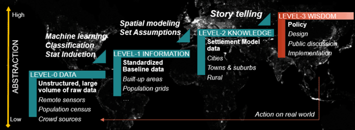
GHSL hierarchy data to wisdom
The GHSL framework develops from a ground 0 comprising unstructured, large volume and heterogeneous raw data coming from satellite, population census and crowd sources.
Data is processed by original methods developed in-house, like symbolic machine learning and other models, to obtain a standardised set of baseline data (level 1 – information) such as the GHSL data contained in the 2019 Data Package (i.e. GHS-BUILT, GHS-POP).
By applying to the level 1 a set of spatial modelling criteria and assumptions, the GHSL framework delivers the Level 2 of abstraction (knowledge), outputting the settlement model data identifying cities, towns and suburbs and rural areas, and making analytics extracting more data for these concepts.
The last hierarchical level is that of wisdom (Level 3) that is achieved making analyses, research and storytelling taking stock of the lower levels. This last level helps policymakers and advances scientific research with new findings.
The data processimg paradigm behing the GHSL
Content of the knowledge section
This section of the GHSL website contains all the knowledge to explains the GHSL concept and the key documents produced by the GHSL: scientific papers and policy reports:
About the GHSL
A brief description of the project, his history and mission.
Documents
The key documents that are either the base or the result of our expertise.
Atlases of the human planet
A periodic release of the new findings related to the human presence on Earth as compiled from the new global evidences gathered by the international scientific community. Every release of the Atlas addresses the mission of the GEO Human Planet Initiative from different perspectives, including the assessment of the human and physical exposure to threats, the impact of human activities on ecosystems, and the human access to resources.
Degree of urbanisation
In its 51st session, the United Nations Statistical Commission endorsed the methodology for delineation of cities and urban and rural areas for international and regional statistical comparison purposes. The method was proposed by a consortium of international organisations (EU, OECD, World Bank, FAO, UN-Habitat, ILO) led by the EU.
This section presents key resources needed for information, visualisation and implementation of the Degree of Urbanisation
ENACT
The ENACT project - ENhancing ACTivity and population mapping aimed at producing consistent, seamless, multi-temporal, high-resolution and validated population density grids for Europe taking into account major daily and monthly variations.
Urban Centre Database
The Urban Centre Database GHS-UCDB R2019A describes more than 10.000 urban centres identified by the application of the "Degree of Urbanisation" model to the GHSL baseline data.