Open and free data and tools for assessing the human presence on the planet
New release: GHS P2023
A new and improved package of datasets have been produced and publicly released on this website
Introduction
The Global Human Settlement Layer (GHSL) project produces global spatial information, evidence-based analytics, and knowledge describing the human presence on the planet.
The GHSL relies on the design and implementation of new spatial data mining technologies that allow automatic processing, data analytics and knowledge extraction from large amounts of heterogeneous data including global, fine-scale satellite image data streams, census data, and crowd sourced or volunteered geographic information sources.
The section below contains a list of the new datasets released with the links to the datasheets.
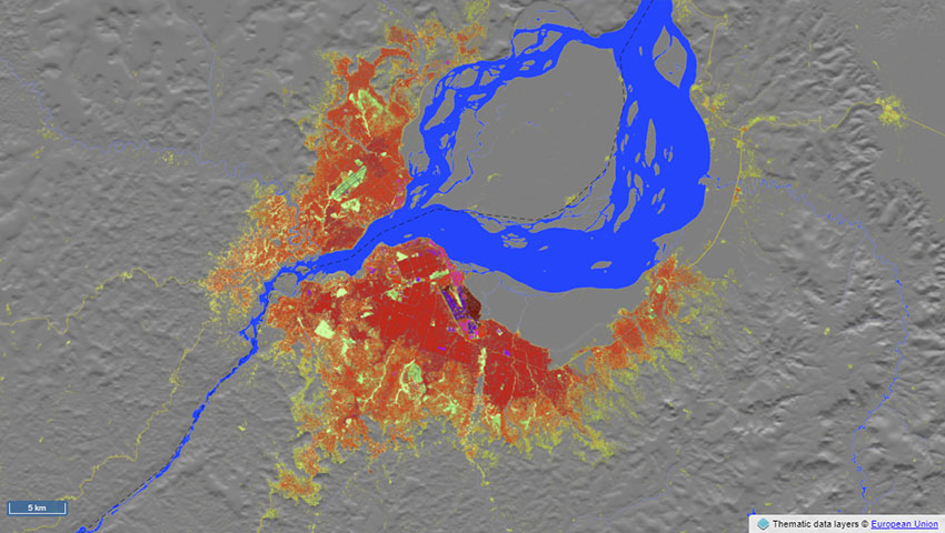
A cropped map zoomed on Kinshasa-Brazzaville, depicting data extracted from the GHSL Data Package 2023.
The data
The GHSL Data Package 2023 consists of multitemporal products, that offers an insight into the human presence in the past (epochs from 1975 through 2020, 5 years interval) and the future (2025 and 2030):
GHS-BUILT-S R2023A - GHS built-up surface grid, derived from Sentinel-2 composite (2018) and Landsat, multitemporal (1975-2030, 5 years interval)
GHS-BUILT-H R2023A - GHS building height, derived from AW3D30, SRTM30, and Sentinel-2 composite (2018)
GHS-BUILT-V R2023A - GHS built-up volume grids derived from joint assessment of Sentinel-2, Landsat, and global DEM data, multitemporal (1975-2030, 5 years interval)
GHS-BUILT-C R2023A - GHS Settlement Characteristics, derived from Sentinel-2 composite (2018) and other GHS R2023A data
GHS-POP R2023A - GHS population grid multitemporal (1975-2030, 5 years interval)
GHS-SMOD R2023A - GHS settlement layers, application of the Degree of Urbanisation methodology (stage I) to GHS-POP R2023A and GHS-BUILT-S R2023A, multitemporal (1975-2030, 5 years interval)
GHS-DUC R2023A - GHS Degree of Urbanisation Classification, application of the Degree of Urbanisation methodology (stage II) to GADM 3.6 layer, multitemporal (1975-2030, 5 years interval)